Submersivity: XR-Guided Underwater Debris Detection
TL;DR
- Submerged garbage in Toronto's Peter Street Basin is hard to see. This system turns RC-submarine video into XR swim-goggle guidance.
- A YOLOv8s detector finds debris, COLMAP + ArUco place it on a basin map, and a Vuzix HUD shows direction, distance and class.
- My part: the detector (TACO mAP50 0.27 → 0.49, multi-class YOLOv8n → single-class YOLOv8s; 92.1% precision) and the Android HUD receiver.
- 토론토 Peter Street Basin의 물속 쓰레기는 잘 보이지 않습니다. 이 시스템은 RC 잠수정 영상을 XR 수경 안내로 바꿉니다.
- YOLOv8s가 쓰레기를 탐지하고, COLMAP + ArUco가 위치를 수조 지도에 올리며, Vuzix HUD가 방향·거리·클래스를 보여 줍니다.
- 담당: 탐지 모델(다중 클래스 YOLOv8n → 단일 클래스 YOLOv8s, TACO mAP50 0.27 → 0.49, 정밀도 92.1%)과 안드로이드 HUD 수신 앱.
- 多伦多 Peter Street Basin 的水下垃圾难以看清。本系统把 RC 潜艇视频转成 XR 泳镜上的引导。
- YOLOv8s 检测垃圾,COLMAP + ArUco 将其标到水池地图上,Vuzix HUD 显示方向、距离和类别。
- 我的部分:检测器(多类 YOLOv8n → 单类 YOLOv8s,TACO mAP50 0.27 → 0.49;精确率 92.1%)和 Android HUD 接收端。
Mann Lab, University of Toronto · Jan.–Jul. 2026 · Built jointly with Chris McGale and Michel A. Herrera Viyella · My part: the debris detector and the native Android XR HUD receiver.Mann Lab, University of Toronto · 2026년 1월 – 7월 · Chris McGale, Michel A. Herrera Viyella와 공동 개발 · 담당: 쓰레기 탐지 모델, 네이티브 안드로이드 XR HUD 수신 앱.Mann Lab, University of Toronto · 2026年1月–7月 · 与 Chris McGale、Michel A. Herrera Viyella 共同完成 · 我的部分:垃圾检测器和原生 Android XR HUD 接收端。
0.27 → 0.49mAP50 on the TACO val split (multi-class YOLOv8n → single-class YOLOv8s)TACO 검증 세트 mAP50 (다중 클래스 YOLOv8n → 단일 클래스 YOLOv8s)TACO 验证集 mAP50(多类 YOLOv8n → 单类 YOLOv8s)
92.1%final detector precision (combined validation set)최종 탐지 모델 정밀도 (통합 검증 세트)最终检测器精确率(合并验证集)
12,177terrestrial + underwater images for fine-tuning미세조정용 지상 + 수중 쓰레기 이미지用于微调的陆地 + 水下垃圾图像
796 / 823survey frames registered by COLMAP for the basin map수조 지도용으로 COLMAP이 정합한 조사 프레임COLMAP 为水池地图配准的勘测帧
SSituation
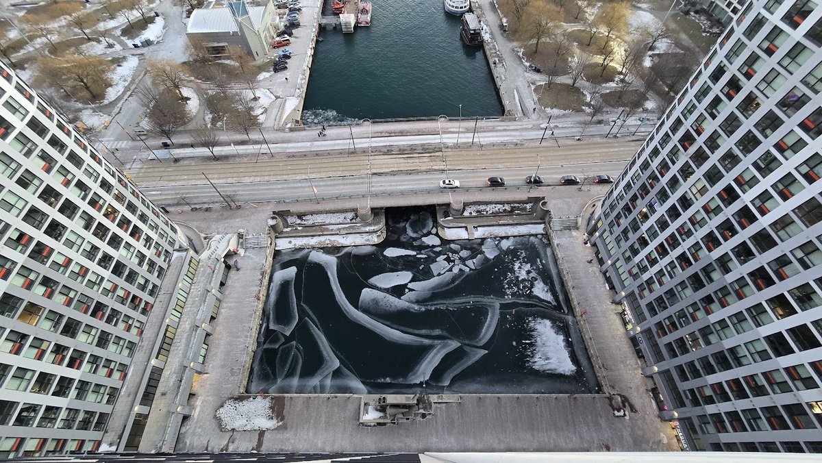
- Peter Street Basin is a roughly 60 m × 30 m outdoor safety basin on Toronto's waterfront, linked to Lake Ontario.
- Cleanup means finding submerged debris. Light attenuation, scattering, particles and colour shift hide it.
- A swimmer has no map of where the garbage is.
S상황
- Peter Street Basin은 토론토 호숫가의 약 60 m × 30 m 야외 안전 수조로, 온타리오 호수와 이어져 있습니다.
- 청소하려면 물속 쓰레기를 찾아야 합니다. 빛의 감쇠, 산란, 부유물, 색 왜곡이 물체를 가립니다.
- 수영하는 사람에게는 쓰레기 위치를 알려 줄 지도가 없습니다.
S情境
- Peter Street Basin 是多伦多湖滨一处约 60 m × 30 m 的户外安全水池,与安大略湖相连。
- 清理需要找到水下垃圾,但光衰减、散射、悬浮颗粒和色偏会让物体难以看清。
- 游泳者也没有标出垃圾位置的地图。
TTask
- Turn underwater video into guidance a swimmer can act on.
- Detect debris from a small RC submarine's camera and place each detection on a basin map. Show the nearest target on XR swim goggles.
- My part in the team: the debris detector and the goggle-side HUD receiver.
T과제
- 수중 영상을 수영하는 사람이 바로 쓸 수 있는 안내로 바꾼다.
- 소형 RC 잠수정 카메라로 쓰레기를 탐지하고, 탐지 위치를 수조 지도에 올린다. 가장 가까운 목표를 XR 수경에 보여 준다.
- 팀 내 담당: 쓰레기 탐지 모델과 고글 쪽 HUD 수신 앱.
T任务
- 把水下视频转成游泳者可直接使用的引导信息。
- 用小型 RC 潜艇的摄像头检测垃圾,并把每个检测结果标到水池地图上;在 XR 泳镜上显示最近的目标。
- 我在团队中的部分:垃圾检测器和泳镜端 HUD 接收端。
AAction
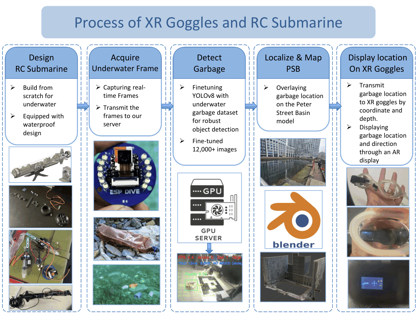
- Sensing: an open-source ESP-DIVE RC submarine with a XIAO ESP32-S3 camera streams frames over Wi-Fi to a laptop for detection.
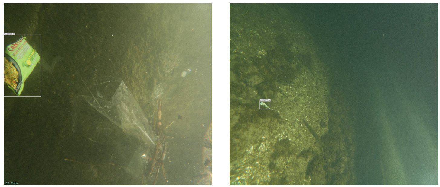
- Detection (my part): a cleanup swimmer does not need “bottle” vs. “can”. So I merged all debris categories into one “garbage” class. Multi-class YOLOv8n → single-class YOLOv8s raised TACO val mAP50 from 0.27 to 0.49. The final YOLOv8s was fine-tuned on 12,177 combined terrestrial and underwater garbage images.
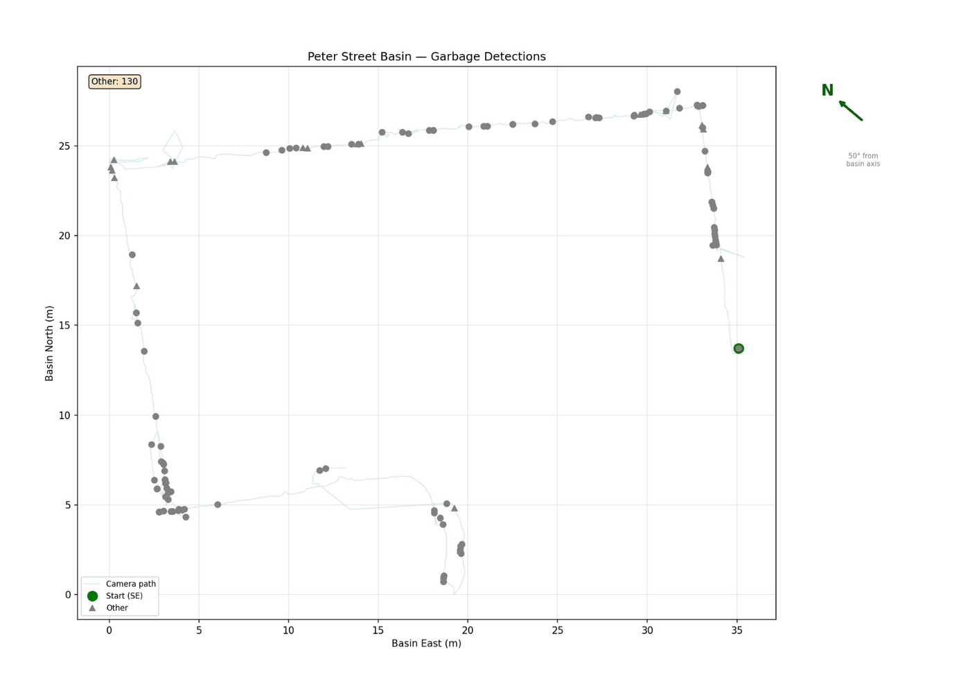
- Localization: COLMAP structure-from-motion plus ArUco markers on the basin walls register camera poses, and thus detections, in basin coordinates.
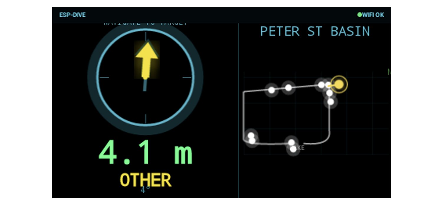
- XR HUD receiver (my part): a native Android app on Vuzix Smart Swim goggles shows the nearest target. It displays a compass arrow, distance, class and a basin mini-map. I built the receiving side: byte-stream packet reassembly, 500 ms stale-data detection, auto-reconnect and a link-quality indicator.
A행동
- 수중 촬영: 오픈소스 ESP-DIVE RC 잠수정의 XIAO ESP32-S3 카메라가 Wi-Fi로 노트북에 프레임을 보내고, 노트북에서 탐지합니다.
- 탐지 (담당): 쓰레기를 줍는 사람에게 병과 캔의 구분은 필요 없습니다. 그래서 모든 종류를 “쓰레기” 한 클래스로 합쳤습니다. 다중 클래스 YOLOv8n → 단일 클래스 YOLOv8s로 TACO 검증 mAP50이 0.27에서 0.49로 올랐습니다. 최종 YOLOv8s는 지상·수중 쓰레기 이미지 12,177장으로 미세조정했습니다.
- 위치 추정: COLMAP SfM(Structure-from-Motion)과 수조 벽의 ArUco 마커로 카메라 위치, 즉 탐지 위치를 수조 좌표계에 정합합니다.
- XR HUD 수신 앱 (담당): Vuzix Smart Swim 고글의 네이티브 안드로이드 앱이 가장 가까운 목표를 보여 줍니다. 나침반 화살표, 거리, 클래스, 수조 미니맵을 표시합니다. 저는 수신부를 만들었습니다: 바이트 스트림 패킷 재조립, 500 ms 오래된 데이터 감지, 자동 재연결, 링크 품질 표시.
A行动
- 水下采集:开源 ESP-DIVE RC 潜艇搭载 XIAO ESP32-S3 摄像头,经 Wi-Fi 把画面传到笔记本电脑上做检测。
- 检测(我的部分):清理垃圾的游泳者无需区分瓶子和罐子,因此我把所有垃圾类别合并为单一“垃圾”类。从多类 YOLOv8n 改为单类 YOLOv8s 后,TACO 验证集 mAP50 从 0.27 升至 0.49。最终的 YOLOv8s 在 12,177 张陆地与水下垃圾图像上微调。
- 定位:COLMAP 运动恢复结构(SfM)结合池壁上的 ArUco 标记,把相机位姿及检测结果配准到水池坐标系。
- XR HUD 接收端(我的部分):Vuzix Smart Swim 泳镜上的原生 Android 应用显示最近的目标,包括罗盘箭头、距离、类别和水池小地图。我负责接收端:字节流分包重组、500 ms 过期数据检测、自动重连和链路质量指示。
RResult
- 92.1% precision on the combined validation set for the single-class detector, fine-tuned on 12,177 images.
- Multi-class YOLOv8n → single-class YOLOv8s: TACO mAP50 0.27 → 0.49.
- The basin map registered 796 of 823 survey frames, giving a basin-aligned trajectory for detections.
- Preliminary field runs: debris detected in poor underwater visibility, with live direction and range cues on the goggles.
- Published at IEEE ICMA 2026 (built jointly with the first two authors).
R결과
- 12,177장으로 미세조정한 단일 클래스 탐지 모델: 통합 검증 세트 정밀도 92.1%.
- 다중 클래스 YOLOv8n → 단일 클래스 YOLOv8s: TACO mAP50 0.27 → 0.49.
- 수조 지도가 조사 프레임 823개 중 796개를 정합해, 탐지가 쌓이는 수조 기준 경로를 만들었습니다.
- 예비 현장 실험: 탁한 수중 환경에서도 쓰레기를 탐지했고, 고글에 방향·거리 안내를 실시간 표시했습니다.
- IEEE ICMA 2026 게재 (제1·2저자와 공동 개발).
R结果
- 单类检测器在 12,177 张图像上微调后,合并验证集精确率 92.1%。
- 多类 YOLOv8n → 单类 YOLOv8s:TACO mAP50 0.27 → 0.49。
- 水池地图配准了 823 帧中的 796 帧勘测画面,得到与水池对齐、可累积检测的轨迹。
- 初步实地测试:在水下能见度差的条件下检测到垃圾,并在泳镜上实时显示方向和距离提示。
- 发表于 IEEE ICMA 2026(与前两位作者共同完成)。